Weathering the Storm
Climate resilience guides the Land Trust’s conservation agenda.
East of Mount Adams, the Klickitat River flows wild and undammed, a thread uniting a dramatic tapestry of talus slopes, basalt cliffs, pine and fir forests, and rolling hills. These contrasting landscapes are more than just visually striking; conservation science suggests they may hold the key to wildlife enduring in the face of climate change.
In 2016, when Columbia Land Trust set out to draft a conservation agenda for the next 25 years, its staff faced a vexing question: How do we conserve land for wildlife when the conditions on which they depend are changing in ways we can’t fully predict?
Defining Climate Resilience
Climate models are useful, but they are limited by our assumptions. Increasingly, conservationists are looking to climate resilience—the measure of a landscape’s capacity for renewal amidst changes in climate—as a tool to identify the places most likely to support wildlife in the future.
“We are mapping resilience,” said Ken Popper, senior conservation planner with The Nature Conservancy, “based on things that will not change due to climate change, such as soils, elevation, and slope of lands.” Sites with diverse sets of these characteristics provide microclimates across which species can move in response to change. Moreover, landscapes that are permeable, or free of barriers such as highways, allow wildlife to travel and take advantage of the terrain’s diversity. Places that are both topographically complex and permeable are considered more resilient. As Cherie Kearney, forest conservation director for Columbia Land Trust, put it, “Areas with above-average climate resilience are like nature’s storm cellars. The more storm cellars we can conserve, the better our region’s wildlife will weather the storms of climate change.”
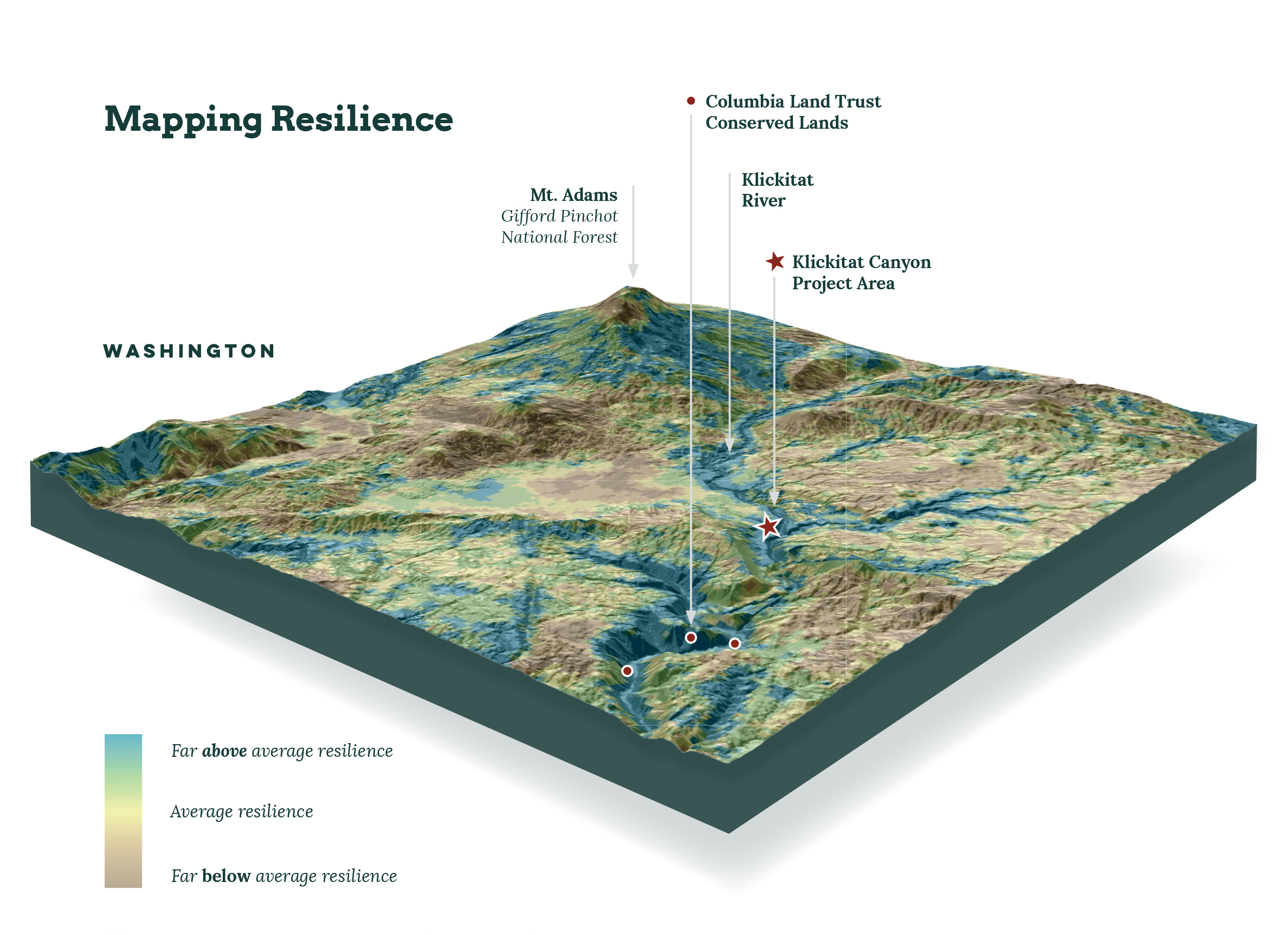
Conservation Opportunities Areas
To inform the Land Trust’s agenda, GIS Manager Tanner Scrivens created a complex map of the lower Columbia River region. First, he integrated The Nature Conservancy’s climate resilience data with data sets measuring current levels of biodiversity and landscape connectivity.* Then he blended those results with local knowledge to map conservation opportunity areas (COAs), our highest-priority lands over the next quarter century.
Klickitat Canyon, with its steep slopes and changes in elevation, sits within a COA that supports an abundance of life. For migrating mule deer, the area serves as a vital link between lowland habitat and higher summer grazing areas on Mount Adams. This year, the Land Trust is working to acquire 3,200 acres in Klickitat Canyon, which will build on 2,400 acres conserved in 2016.
Looking forward, we know some wildlife species will have to move to survive a changing climate. By leveraging science and working together, conservation groups are improving the odds for wildlife in the Pacific Northwest for years to come.
*The Land Trust was able to apply The Nature Conservancy’s climate resilience data to its conservation agenda planning thanks to a generous technical assistance grant from the Doris Duke Charitable Foundation. The foundation is also supporting our second-phase Klickitat Canyon acquisition through a land protection grant aimed at landscapes with above-average climate resilience.